The Azure-Snow-Cascade Lakes Loop Hike
By Ken Johnson Lot 8
If you've done the Tallac hike for the umpteenth time and would like to try
something a little different, I highly recommend the loop hike from Bayview
Campground (above Emerald Bay) up Maggie's Peak and back down by way of Azure
Lake, Snow Lake, and Cascade Lake (which is just over the ridge from Spring
Creek). This is a real gem of a hike, although it isn't reviewed in any
trail-guide books that I've seen.
I did this
hike in early September 2011 with Olaf Perfler (Lot 110, Pomo) and several
times in October with an assortment of friends and relatives. On my last
excursion, on October 30, I went solo taking the clockwise route. I
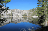
started out by starlight, watched the first light of dawn breaking over Cascade
Lake, and got up to the higher lakes while the waters were still calm and
glassy smooth. (See attached pic's.)
If you would like to try this hike, here are some pointers:
For first-time hikers, it is preferable to take the counterclockwise route, as
it is easier to follow the (somewhat sketchy) trail along Cascade Creek coming
down. From Bayview Campground, take the right trail branch up Maggies
Peak. You might want to make a wayside stop at the peak. From the
south end of the peak you can get a bird's-eye view of the route you will be
taking. (See pic.)
After rejoining the main trail, look for the cutoff to Azure Lake soon after
the trail starts to head downhill. Jake's Peak will disappear behind a
saddle on your right, the trail will briefly level out, and at that point the
cutoff trail to Azure will be down a gully to your left. From there it is
about a half-hour walk to Azure Lake. (Stop on the way to inhale the
coyote mint, and watch out for the inconspicuous right turn in the trail about
half-way down.) When you reach the lake, turn right and follow the
shoreline to a nice tree-shaded picnic/rest area at the north end of the lake.
After awaking from your nap, retrace the trail along the east shore down to the
stream outlet at the south end of the lake. The trail will eventually run into
some impassable rocks, but shortly before that point there is a branch trail up
a ravine, leading to an easy route above the rocks down to the stream.
You need to cross the stream and traverse southward a little way to find a good
route down the hill. (This part of the hike is off-trail -- just follow
your nose and common sense. It helps to have reviewed the route on Google
Earth beforehand.) After you're down the hill, head east over to Snow
Lake, where you can take time out for another snooze.
Next, you will head north-northeast along Cascade Creek down to Cascade
Lake. You will need to do a stream crossing to get on the left (west)
side of the two tributaries coming out of Azure and Snow Lakes.
Thereafter you should never cross the stream again; stay on the west side all
the way down. If you lose the trail, just follow the stream and it will
sooner-or-later turn up again. You will eventually pass a magnificent
waterfall; and a while later the trail will dead-end at a jumble of rocks,
which you will have to traverse to rejoin the trail. There are actually
two trail branches from that point. The one closer to the stream is very
swampy, so take the leftmost route. That will take you to Cascade Lake,
and the main trail along the lake leads back to Bayview Campground.
The hiking time (including
nap time) is around six hours. The highest elevation point is Maggie's
Peak, about 8600 ft, and it's basically all downhill from there. This
should be approached as a serious back-country hike, so research the route
beforehand and bring along your map, compass, poncho, bear spray, plenty of
food and drink, etc. A terrain map can be found at the following link:
http://www.tahoebackcountry.net/hiking/desolation/images/maggies_velma_map.jpg
Google Earth is also a good resource, but the June 2011 imagery is useless
because everything is buried in snow. (Select View --> Historical
Imagery and scroll back to June 2009.)
Enjoy the hike, and we might cross paths along the way! :-)
More Hikes:
I’ve had requests to re-publish Tom Frankel’s great article on hikes from Spring Creek Tract.
 Tales From Tallac
• Spring 2011 • TALES FROM
TALLAC
Tales From Tallac
• Spring 2011 • TALES FROM
TALLAC
35 YEARS OF GOOD HIKES
FROM SPRING CREEK TRACT
by Tom Frankel
All of the following hikes are in the a r e a o f Spring Creek Tract Detailed information on each of them is available from many excellent Tahoe area guidebooks and maps, or I am happy to give more information. All of the hikes have fine picnic sites. These hikes are not listed in any particular order.
North side of Fallen Leaf Lake as far as you want to go: This is an easy walk that includes Lucky Baldwin’s burnt-out roadhouse and great views of the lake, meadows and Tallac. Drive in on the paved road on the north side of Taylor Creek. About 1 mile in there is parking near Taylor Creek. Follow the trail that parallels the creek. There is a dam at the top of Taylor Creek. If you cross the dam there are great rocky beaches along Fallen Leaf Lake. If you stay right, the trail ultimately hooks up with the trail that comes down from Mt. Tallac.
South side of Fallen Leaf Lake along lake edge: The trail is about ½ mile beyond the Fallen Leaf
campground. Park by the side of the road. It is about 1 mile to great beach spots on Fallen Leaf and then follow the left side of the lake as far as desired.
Up the ridge between Spring Creek Tract and Cascade Lake: Walk to the end of Mattole Road and continue on the dirt road approximately 1 mile to where a dirt road/trail goes uphill to the ridge. The trail is approximately 1 mile uphill and ends overlooking Cascade Lake.
Spring Creek Tract to Floating Island Lake, Cathedral Lake and the top of Mt. Tallac:
This trail, which is not for beginners, leaves from the left side of Spring Creek Road near its top. It used to be the maintained trail up Tallac. An alternative to the top of Tallac or to Fallen Leaf Lake is to park at the Mt. Tallac trailhead lot near Camp Concord. That maintained trail hooks up with the trail from Spring Creek Tract at Floating Island Lake. It is marked and there is a split in the trail below Cathedral Lake. Take the left branch to Fallen Leaf Lake.
Bottom of Emerald Bay: Park in one of the lots at Emerald Bay and walk about one mile down to Vikingsholm, where there are tours in the summer. Behind the mansion about ½ mile is the bottom of Eagle Falls. Especially in the spring this is a beautiful sight. From Vikingsholm, go either to the left as you face the water to Bliss State Park or to the right to Eagle Point. These are beautiful lake- edge trails. The trail to Eagle Point is minimally used. Both directions include lovely waterside beaches and coves. Bliss State Park includes a great public (and often crowded) beach. You can also drive into Bliss and park near the beach. From there you can walk in the other direction to Emerald Bay.
Balancing Rock in Bliss State Park: This is a short (loop about 1 mile) easy walk and children love t h e h u g e b o u l d e r s g r e a t f o r climbing. Included is a very large balancing rock. There is an easy, well-marked path with nature markers.
Near the Fallen Leaf Lake Lodge up Alpine Creek (and Falls) to Glen Alpine Springs: Drive about
1 mile beyond the store/restaurant at the far end of the road around Fallen Leaf Lake. The road turns left up the mountain, paralleling the creek and falls. There are parking areas near the various falls, which are great picnic spots. There is a parking lot at the end of the road leading to a well-marked road/trail. The springs used to be a resort designed by famous architect
Bernard Maybeck. It is now maintained by a nonprofit organization. There is still natural spring bubbly water that historically was bottled and sold. The trail continues into Desolation Wilderness above the springs next to the creek and more waterfalls/ pools. It is about 2 miles to Glen Alpine Springs.
Various paths from Echo Lakes: Drive up to Echo Summit and turn right into Echo Lake. Park where designated near the store/restaurant. There is a boat taxi that is lots of fun. It runs as needed and takes people across the 2 lakes to the trailhead into Desolation Wilderness. From the trailhead there are many hikes, including great day hikes to Cagwin Lake, Ralston Lake, and Tamarack Lake. These are kid doable and give a good sample of what the interior of Desolation is like. There are also wonderful views of Desolation Wilderness. Distances on these trails are as far as you want to go. The first lake beyond Echo is abou3 miles. There is also a trail around Echo Lake from the same starting place, which includes a chance to sit on the huge rocky mountainside that we see when we travel on Highway 50 below Echo Summit.
South Side of Echo Summit: Drive up to the top of Echo Summit and turn left into the old Echo Summit Ski area parking lot (now used as a winter play area). The Pacific Crest Trail goes through this area and you can travel on it toward Benwood Meadow. The trail, which is quite level, loops around a small lake. You can go as far as you want on this trail.
Cascade Falls: Drive to the first parking lots at Emerald Bay (Bayview). At the end of the parking area away from the road is a trailhead. Take it and then go on the left fork of the trail that winds around Cascade Lake to Cascade Falls, which feeds into the lake. This is a medium level hike and it is beautiful, with great views of Tahoe. Kids do love it. The hike is about 2 miles each way.
A couple of gentle walks: There are many easy walking trails around the Visitor Center, Taylor Creek, and the mansions near Camp Richardson. There is a tour of the Pope Mansion available. The stores and artist demonstrations are worthwhile. Sugar Pine Point State Park is beyond Emerald Bay on the west side of Tahoe. There are short walks, a fine beach, and tours of the mansion available.